Drought is a complex phenomenon which is difficult to monitor and define. Hurricanes, floods and eartquakes, for example, have a definite beginning and end and can easily be seen as they develop. Drought, on the other hand, is the absence of water. It is a creeping phenomenon that slowly sneaks up and impacts many sectors of the economy, and operates on many different time scales (NCDC-NOA ).
Following Mishra et al. (2007), a drought may mean different things to different people. For example, it is a deviation from normal precipitation for a meteorologist; a fall in streamflow, lake level or groundwater level for a hydrologist; lack of soil moisture to sustain crop growth for an agricultural scientist; a famine condition for an economist, and shortage of tap water supply for an urbanite (Dracup et al. 1980). Thus, a precise and objective definition of drought is lacking and it sometimes contributes to indecision and inaction on the part of managers, policy makers, and others (Wilhite et al. 1986).
Drought definitions vary depending on the variable used to describe it. Differences in hydrometeorlogical variables and socioeconomic factors, as well as the stochastic nature of water demands in different regions around the world, have become an obstacle to have a precise definition of drought. Yevjevich (1967) stated that the diverse definitions are one of the principal obstacles for drought research. When defining a drought, it is important to distinguish between conceptual and operational definitions (Wilhite and Glantz, 1987). The conceptual definitions are those stated in relative terms (e.g., a drought is a long dry period), on the other hand, the operational definitions attempt to identify the onset, severity, and ending of drought periods. Generally operational defined droughts can be used to analyze frequency, severity, and duration of certain return period (for example, Mishra and Singh, 2009).
Meteorological drought is defined as the lack of precipitation over a region for a period of time. Precipitation has been commonly used for meteorological drought analysis (Pinkayan, 1966; Santos, 1983; Chang, 1991; Eltahir, 1992). Considering drought as precipitation deficit regarding average values (Gibbs, 1975), several studies have analyzed them using monthly precipitation data. Other approaches compare drought duration and intensity related to cumulative precipitation shortages (Chang and Kleopa, 1991; Estrela et al., 2000).
Hydrological drought is related to a period with inadequate surface and subsurface water resources for established water uses of a given water resources management system. Streamflow data have been widely used for hydrologic drought analysis (Dracup et al., 1980; Sen, 1980; Zelenhasic and Salvai, 1987; Chang and Stenson, 1990; Frick et al., 1990; Mohan and Rangacharya, 1991; Clausen and Pearson, 1995). From regression analysis relating droughts in stream flow with catchment properties, it is found that geology is one of the main factors that influence hydrological droughts (Zecharias and Brutsaert, 1988; Vogel and Kroll, 1992).
Agricultural drought, usually, refers to a period with declining soil moisture and consequent crop failure without any reference to surface water resources. A decline of soil moisture depends on several factors. This factors affect meteorological and hydrological droughts and the relation between actual evapotranspiration and potential evapotranspiration. Plant water demand depends on prevailing weather conditions, biological characteristics of the specific plant, the stage of growth, and the physical and biological properties of the soil. Several drought indices, based on a combination of precipitation, temperature and soil moisture, have been derived to study agricultural droughts.
Socio-economic drought is associated with failure of water resources systems to meet water demands associating droughts with supply of and demand for an economic good (water) (AMS, 2004). Socio-economic drought occurs when the demand of a good exceeds supply as result of a weather-related shortfall in water supply.
Ecological drought is defined as a prolonged and widespread deficit in naturally available water supplies (including changes in natural and managed hydrology) that create multiple stresses across ecosystems (Lake, 2003).
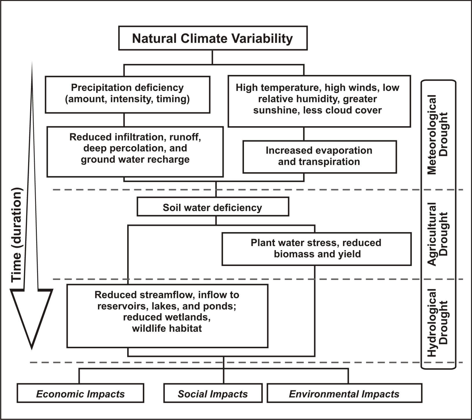
Fig. 1. Sequence of drought occurrence and impacts for commonly accepted drought types. All droughts originate from a deficiency of precipitation or meteorological drought, although other types of drought and impacts are derived from this deficiency. (Source: National Drought Mitigation Center, University of Nebraska-Lincoln, U.S.A.).
Drought indices are quantitative measures that characterize drought levels by assimilating data from one or several variables (indicators) such as precipitation and evapotranspiration into a single numerical value. The use of an index is more convenient than the raw indicator data. The nature of drought indices reflects different events and conditions; they can reflect the climate dryness anomalies (mainly based on precipitation) or the delayed agricultural and hydrological impacts such as soil moisture loss or lowered reservoir levels. In addition, the categorization of drought indices can also be based on the data and technology used. For example, a considerable number of indices use remote-sensing imagery to detect vegetation health as indicator of drought.
Along with precipitation deficit, additional variables such as evapotranspiration and stream flow are also used to more comprehensively characterize drought. Using different models (e.g., water balance/hydrological models), such variables or indicators are combined to derive a drought index. Such indicators can be meteorological, hydrological, or water supply-and-demand in nature. Meteorological indicators include precipitation and cloud cover; hydrological indicators include stream flow and groundwater level; water supply-and-demand indicators include reservoir storage. In practice, however, some indicators such as precipitation, potential evapotranspiration, soil and vegetation cover characteristics have had wider applications and influence (Tsakiris and Vangelis 2005).
Several drought indices have been derived in recent decades. Commonly, a drought index is a prime variable for assessing the effect of drought and defining different drought parameters, which include intensity, duration, severity and spatial extent. It should be noted that a drought variable should be able to quantify the drought for different time scales. For this purpose, long time series are essential. The most commonly used time scale for drought analysis is a year, followed by a month. Although the yearly time scale is long, it can also be used to abstract information on the regional behavior of droughts. The monthly time scale seems to be more appropriate for monitoring the effects of a drought in situations related to agriculture, water supply and ground water abstractions (Panu and Sharma, 2002). A time series of drought indices provides a framework for evaluating drought parameters of interest.
A number of different indices have been developed to quantify a drought, each with its own strengths and weaknesses. They include the Palmer drought severity index (PDSI; Palmer 1965), rainfall anomaly index (RAI; van Rooy, 1965), deciles (Gibbs and Maher, 1967), crop moisture index (CMI; Palmer, 1968), Bhalme and Mooly drought index (BMDI;Bhalme andMooley, 1980), surfacewater supply index (SWSI; Shafer and Dezman, 1982), national rainfall index (NRI; Gommes and Petrassi, 1994), standardized precipitation index (SPI; McKee et al., 1993, 1995), and reclamation drought index (RDI; Weghorst, 1996). The soil moisture drought index (SMDI; Hollinger et al., 1993) and crop-specific drought index (CSDI; Meyer and Hubbard, 1995) appeared after CMI. Furthermore, CSDI is divided into a corn drought index (CDI; Meyer and Pulliam, 1992) and soybean drought index (SDI; Meyer and Hubbard, 1995), and vegetation condition index (VCI; Liu and Kogan, 1996). Besides these indices, indices of Penman (1948), Thornthwaite (1948, 1963), and Keetch and Byram (1968) have been used in limited cases (Hayes, 1996). Heim (2002) gave a comprehensive review of 20th century drought indices used in the United States.
Based on the studies of drought, practically all indices use precipitation either singly or in combination with other meteorological elements, depending on the type of requirements. This requirements were also suggested by WMO (1975). For example, a combination of hydrometeorlogical variables includes: temperature and precipitation (Marcovitch’s index, 1930; Palmers index, 1965; Crop moisture index, 1968), precipitation and soil moisture (moisture adequacy index, 1957; Keetch-Bryam drought index, 1968) and only precipitation (SPI, 1993).
The commonly used drought indices are mentioned ahead:
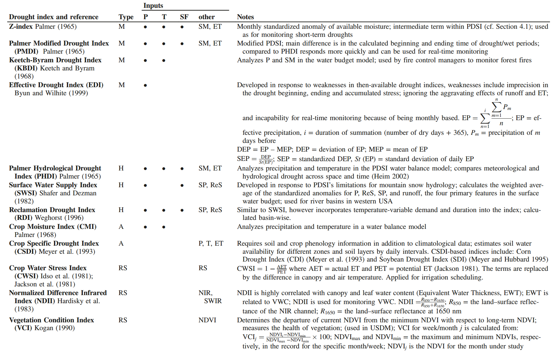
Table 1. Additional notable drought indices (P: precipitation, SF: streamflow/runoff, SP: snowpack, ReS: reservoir storage, T: temperature, ET: evapotranspiration, SR: soil moisture, BT: brightness temperature, EV: evaporation, VWC: vegetation water content, M: meteorological, H: hydrological, A: agricultural, RS: remote sensing, NIR: near-infrared and SWIR: short wave infrared). (Source: Zargar et al. 2011).
According to Art. 314 of the Water Code “The President of the Republic, on request or report from the General Water Directorate may, in times of extraordinary drought, declare shortage areas for maximum periods of six months, non-extendible”. As set out in the Water Code, one of the actions available for adequate water management in times of extraordinary drought is the so-called Declaration of Water Shortage Zone, which allows decisions regarding water in natural sources and manage water resources in a way that strictly limits the damage from water scarcity. This declaration is faculty of the President of the Republic and is processed on the request or with the DGA report and has a maximum non-extendible six months. Among the measures that the DGA can apply are: to authorize the extraction of groundwater or surface water in any location and without the need of constitute water use rights and without the limitation of maintaining the minimum ecological flow. To distribute or redistribute the natural stream or channel water, where the DGA may suspend the section and attributes of Boards of Vigilance.
According to Resolution No. 1674 DGA, 12 June 2012:
The hydrometeorological information for determining extraordinary droughts will be the rainfall, river flows, volume of reservoirs and conditions of the measured aquifer stations controlled by the Directorate General of Water or other entities responsible for hydrometeorological measurements.
To determine extraordinary drought periods, in the case of surface water, the considered indicators are:
a) Standardized Precipitation Index (SPI); and b) Standardized Runoff Index (SRI).
Therefore, the aforementioned indicators allow to check the condition of drought in a certain zone, considering rainfall and river flows. The hydrometeorological conditions for a period of extraordinary drought are that:
a) The cumulative precipitation counting from April, in order that the period of April-August must remain covered, rainfall must have an indicator of drought (SPI) equal or lower than -0,84. b) The consecutive mean monthly cumulative discharge in the last three months, have an indicator of drought (SRI) equal to or lower than -0,84.
In the case of groundwater use, drought conditions will be verified, if at any time, in a hydrogeological sector of common usage of the aquifer, the capacity of the water supply exploitations comply with the following:
a) In the case of water companies, when the informed capacity to the SISS lowers by 50% compared to the last rate process. b) In the case of rural drinking water systems, when the granted rights for groundwater use lowers by 50%.
According to MINAGRI-FAO (2011), the declaration of Agricultural Emergency shall be supported by the technical report of the Institute of Agricultural Research (INIA), which is prepared according to information that the institute possesses and the provided by the Agrometeorological network, containing:
a) Meteorological data of the affected area. b) Maps with major agrometeorological indicators. c) Report of the agrometeorological situation by region and by items. d) Technical recommendations to address the hazard.
This report will be constantly updated according to the availability of the Ministry new technologies for the corresponding technical teams. As a way to obtain the report with qualified regional actors, it is recommended the creation of an Advisory Committee formed by leading professionals in the region (public and private) to validate, complement or amend the agrometeorological information generated. The technical report will be discussed in the Regional Emergency Commission of Agriculture and Agro-Climatic Risk Management along with other reports that might have to complement the analysis of the situation affecting a particular territory. The product of this instance must be oriented to advise decision making related to the application of the agricultural emergency declaration made by the SEREMI, who will course or reject the application. With all the background information provided, the regional authority (“Intendente”) evaluates the presentation and decides finally if it must be sent to the Minister of Agriculture or not. If the declaration of agricultural emergency is decreed, must be companied by an action plan and a budget detailing:
a) The mitigation measures that respond to the needs and identified risks both, in the Technical Report prepared by the INIA, and the recommendations from the CREA respectively; b) The estimated cost of each of the proposed mitigation measures; c) A financing plan of such measures that considers the use of different existing funding sources at national and regional level. Subject to submission of the application, each Regional Mayor shall submit to the Regional Advisory Commission, the water situation in the region, plan mitigation measures, cost and funding sources. The Minister, in discussion with the Technical Committee of the National Emergency Commission Agriculture and Risk Management Agroclimatic (CNEA), has the capacity to declare or not agricultural emergency signing a special resolution in order to end this procedure.
The following diagram shows the agricultural emergency declaration procedure:
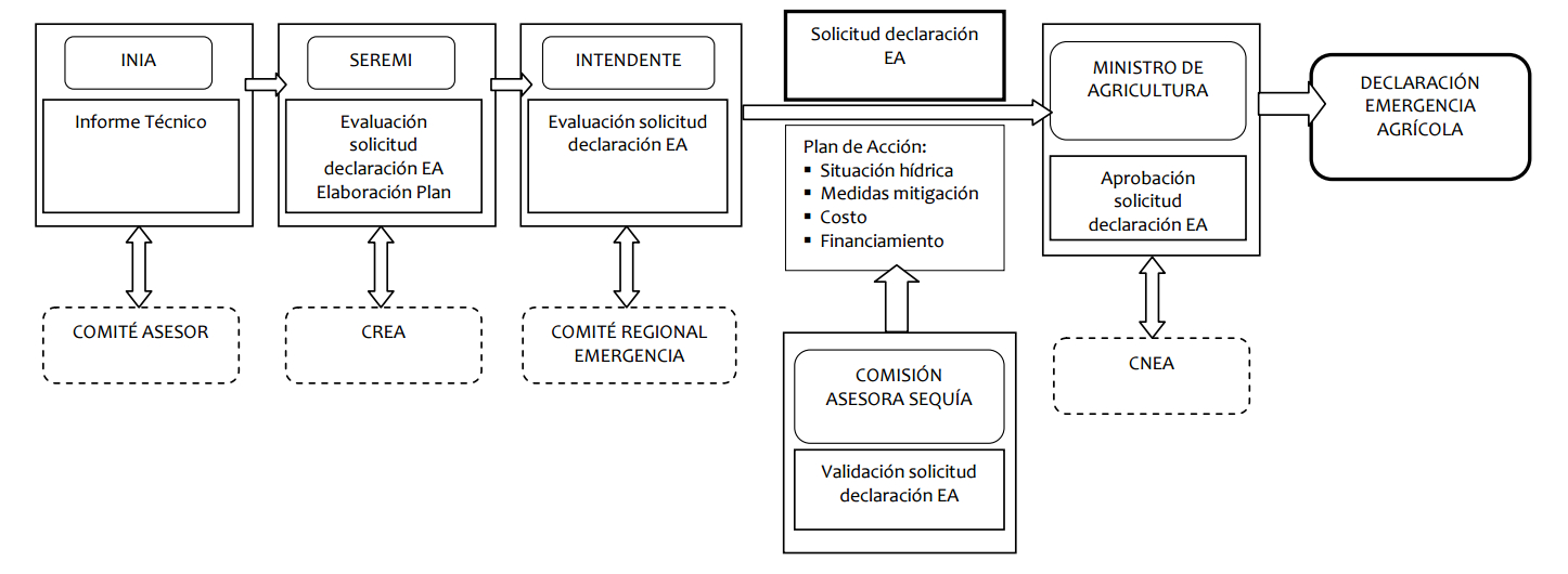
Fig. 2. Agricultural emergency declaration procedure MINAGRI-FAO (2011).
The Agricultural Emergency decree guarantees to the affected producers aid delivery in an efficient way, this with a permanent monitoring by the local authorities.